GR52 Bivouac Dossier
Yarden and Ayelet land in Nice on Friday 11 September, sleep in Saint-Dalmas, walk seven days to Menton with a tent. Their stage split, with the technical options named.
The plan
Yarden and Ayelet's split, which is the official FFRandonnée staging. Times are guidebook times plus 20 %. The GPX layers in your Downloads folder match these nights.
Land in Nice 09:45 → a few hours in town → bus 90 → Saint-Dalmas
The tight bit. Bus 90 runs Nice to La Bolline three times a day on weekdays, at 08:10, 16:40 and 18:40 from Les Arboras, passing Grand Arénas a few minutes later. The 16:40 arrives around 18:40; the 18:40 arrives after check-in closes. Take the 16:40, be at Grand Arénas by 16:15, and phone the hostel on +33 4 22 49 01 06 in the morning to say you arrive about 18:45. Booked: twin room at HI hostel "Le Chalet", breakfast included, restaurant on site for dinner, check-out by 10:00.
Nice, 10:30 to 16:00. Tram 2 from the airport to Grand Arénas is one stop, so leave the packs in a locker there or carry them. Buy six days of food (rice, lentils, salami, cheese, carrots, onion) and a gas cartridge, which cannot fly with you, at the Decathlon or a supermarket near Grand Arénas. Then tram into the old town: Cours Saleya market for lunch, the Castle Hill viewpoint, the Promenade. Be back on tram 2 by 15:45.
Saint-Dalmas → Col de Veillos → Col du Barn → Salèse valley → Le Boréon
The longest day, straight after travel. Breakfast at 07:00, walk by 08:00, and you arrive around 18:30. Water at a spring on the way up and at Lac Petit; nothing on the col. Col du Barn (2,452 m) is the park boundary; the trail then swings through the Salèse valley on the line restored after Storm Alex. Le Boréon is outside the core, so no 19:00 rule: the lake is beside the road, and one report paid €10 to pitch at the horse ranch. Dinner out 1: the hotel-restaurant at Le Boréon. If you are behind schedule at Lac Petit by 14:00, sleep there and finish the stage in the morning.
Le Boréon → Lac de Trécolpas → Pas des Ladres → Madone de Fenestre
Short and steep. Trécolpas to Pas des Ladres (2,448 m) is one of the three sections the French guides flag. Camping is banned around Madone de Fenestre. Two legal options: a bed at the refuge (62 places, open to 30 September, book online, dinner served), or carry on one hour to Lac de Fenestre (2,266 m) and bivouac there inside the core. The refuge bed is the comfortable choice and shortens day 3 by nothing; the lake shortens day 3 by an hour.
Madone de Fenestre → Pas du Mont Colomb → Refuge de Nice
The technical day. Pas du Mont Colomb (2,548 m): scree to a narrow breach with a 2–3 m rock step, fine dry, not in rain. Boulders down to the refuge; the footbridge is gone, so a ford. Short day, so this is where Mont Colomb (2,816 m, off-trail scramble, 2–3 h) fits if the rock is dry and you have the topo.
Refuge de Nice → Baisse du Basto → Refuge des Merveilles
Over the high point (2,693 m) into the Vallée des Merveilles: marked trail only, no touching engravings. Afternoon: Mont Bégo (2,872 m, +750 m, easy, sea view) or the guided engraving walk. Refuge dinner available, cash only.
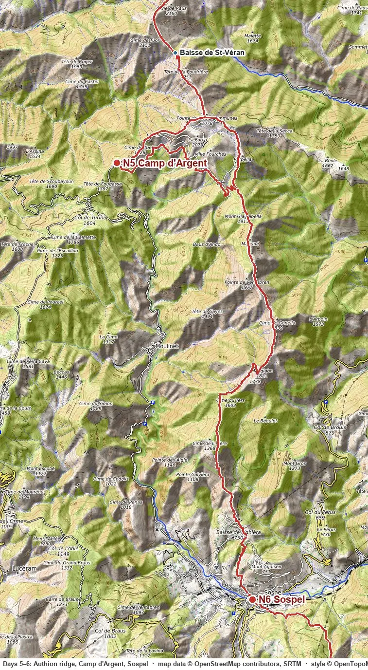
Merveilles → Pas du Diable → Authion ridge → Camp d'Argent
No water after the refuge until Camp d'Argent: leave with 3 L each. Option: Cime du Diable (2,685 m, +2 h) from the pass. Dinner out 2: L'Estive gîte, open to 1 October; ask where to pitch.
Camp d'Argent → Sospel
Long, steep, hot descent. Start early. Sospel has shops, a bakery and a station on the Nice–Tende line. Dinner out 3: Sospel, by the old bridge. Fill every bottle for tomorrow.
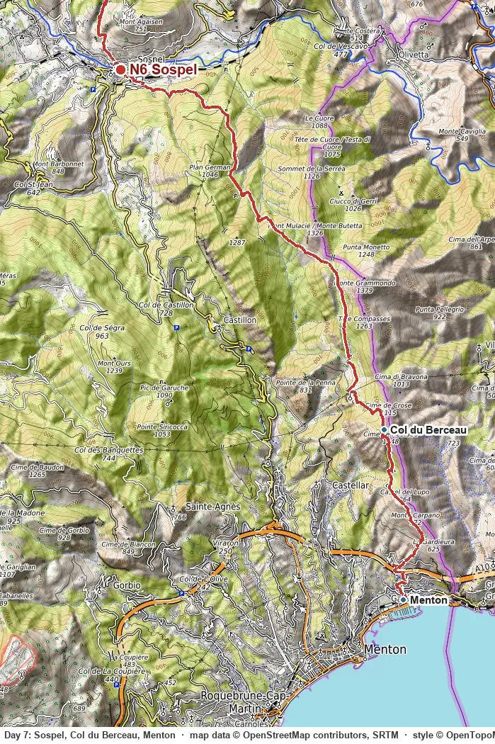
Sospel → Col du Berceau → Menton
No water at all in a dry September: 3 L each. The last hour below Col du Berceau (1,090 m) is steep and loose. Then the sea.
Maps and profile
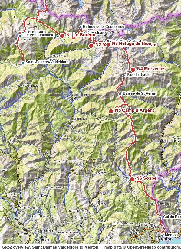
This map is drawn live from the same GPX file you can download here, so the two never differ. Each day's Map tab shows its own stretch and profile; this is the whole route. Twist with two fingers or use the arrows to rotate; the compass resets north. Tap any line or dot for its note. The layers button toggles each track and each kind of waypoint, the same list as in the GPX. "Where am I" shows your position, the kilometre on the route and the distance to the next night. "Save this area offline" stores the visible map tiles in the browser; the page and the GPX are stored automatically, so the site keeps working without signal. Add it to your home screen for an app-like view. Base map OpenTopoMap; planning aid only, carry IGN 3741 OT and 3841 OT.
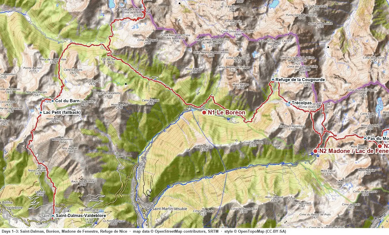
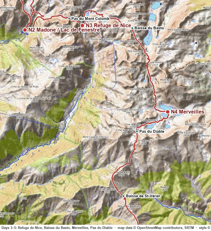
Annotated section maps, for printing or offline
Rules and water
Park core (Col du Barn to just past Pas du Diable): low tent, new spot each night.
Merveilles zone: bivouac only on the marked area behind the Refuge des Merveilles. Stay on the trail.
Dry stretches: Merveilles → Camp d'Argent and Sospel → Menton. Nothing mapped, nothing in any report. 3 L each.
| Place | Alt. | Open | Tent | Note |
|---|---|---|---|---|
| Saint-Dalmas-Valdeblore | 1,290 m | village | HI hostel, booked 11 Sep | bus 90, small shop, taps |
| Le Boréon | 1,500 m | hotel-restaurant | night 1: lake or ranch, ≈€10 | dinner out 1 |
| Refuge de la Cougourde | 2,100 m | to 19 Sep | Trécolpas, 30 min | tap, showers |
| Madone de Fenestre | 1,903 m | to 30 Sep | night 2: refuge bed, or Lac de Fenestre 1 h above | tap, dinner, road |
| Refuge de Nice | 2,232 m | to end Sep | by the lake | tap; footbridge gone, ford |
| Refuge des Merveilles | 2,130 m | to end Oct | marked area only | tap, cash only, guided walks |
| L'Estive, Camp d'Argent | 1,750 m | to 1 Oct | ask | dinner, tap, road to Turini |
| Sospel | 350 m | village | Camping Sainte-Madeleine | shops, station, fountains |
Technical options and via ferrata
On the line: Trécolpas to Pas des Ladres (steep, blocky), the Pas du Mont Colomb rock step (T3 dry), boulders below Baisse du Basto, and two long loose descents where the reports' injuries happen. Beyond that:
| Objective | From | What it is | Time |
|---|---|---|---|
| Via ferrata Baus de la Frema | La Colmiane, bus 90 stop above Saint-Dalmas | Grade D, TD variant. 40 m footbridge, overhangs, summit 2,246 m. €6 access, €21 kit, book 24 h ahead, closed in rain. | 4–5 h + 1 h down |
| Mont Bégo 2,872 m | Refuge des Merveilles | Cairned walk, no difficulty, +750 m. | 3–4 h |
| Cime du Diable 2,685 m | Pas du Diable | Steep marked path via Pas du Trem. | ≈2 h |
| Mont Colomb 2,816 m | Pas du Mont Colomb | Off-trail scramble, dry rock and topo needed. Needs the spare day. | 2–3 h |
| Cime du Gélas 3,143 m | Madone de Fenestre | AD couloir, rockfall when dry. Skip in September. | — |
| Roya via ferratas | Tende, La Brigue, by train from Sospel | Easy to moderate, guided ≈€50. Only for a spare day. Peille's L'Escale is closed. | half day |
Practical
September
- Storms rare, unlike July and August. Valley highs 20–24 °C, 0–5 °C at the high bivouacs, frost possible.
- First snow on Colomb and Basto is possible from mid-September. If it falls, wait a day.
- Sunrise ≈07:10, sunset ≈19:45.
- Live forecast: each day card above shows the current forecast for that day's night spot and high point, from Open-Meteo, refreshed every time the page loads, with warnings derived for thunderstorms, rain, snow and freezing level, ridge wind, frost, heat, fog and UV. The last forecast is kept for offline reading.
- Official sources to check the day before: Météo-France vigilance, Alpes-Maritimes (colour warnings for storms, rain, heat), Météo-France mountain bulletin, Mercantour (freezing level, wind at 2,000 and 3,000 m, storm timing), park trail notices.
- Trail notices (park site, 4 Sep): Boréon line reopened; fords at Cougourde and Refuge de Nice. Re-check Info sentiers before leaving.
Transport
- Nice → Saint-Dalmas: bus 90, weekdays 08:10, 16:40, 18:40 from Les Arboras via Grand Arénas, ≈2 h. Confirm on the Lignes d'Azur app the week before.
- Bail-outs: Madone de Fenestre road, Col de Turini road, Sospel station.
Gear
- Sleeping bag and mat.
- Walking poles.
- 3 L capacity each.
- Six days of food from Nice (rice, lentils, salami, cheese, carrots, onion), so the refuges are extras. Cash for refuges.
- Offline maps: the GPX in any map app that reads it, plus IGN 3741 OT and 3841 OT.
- Hang food: foxes and boar raid tents by the lakes.
- Headtorch; you will cook at dusk.
- Emergency: 112.
Links
Trip reports
- Happily Ever Travels, 6 days wild camping in August. Closest to your plan.
- Altitude Rando, 15–22 September, campsites and refuges. Same dates as yours.
- Randonner Léger 2025 and Larche to Menton, ultralight bivouac, French.
- GR Five, best description of the Sospel descent.
- Crossing the Alps with Ease, refuges, 2022.
- Howlingmist, late October, the cold end of the season.
- Wikiloc, 5-day bivouac, reversed.
- FKT, Menton to Lake Geneva via GR52 and GR5: 12 d 20 h, September 2025.
Official
- Mon GR, Topo de Rando, GR Infos: stages.
- Park rules FAQ, bivouac order, Merveilles zone.
- AllTrails stage list, recent reviews.
- La Colmiane via ferrata booking, all via ferratas in the 06.