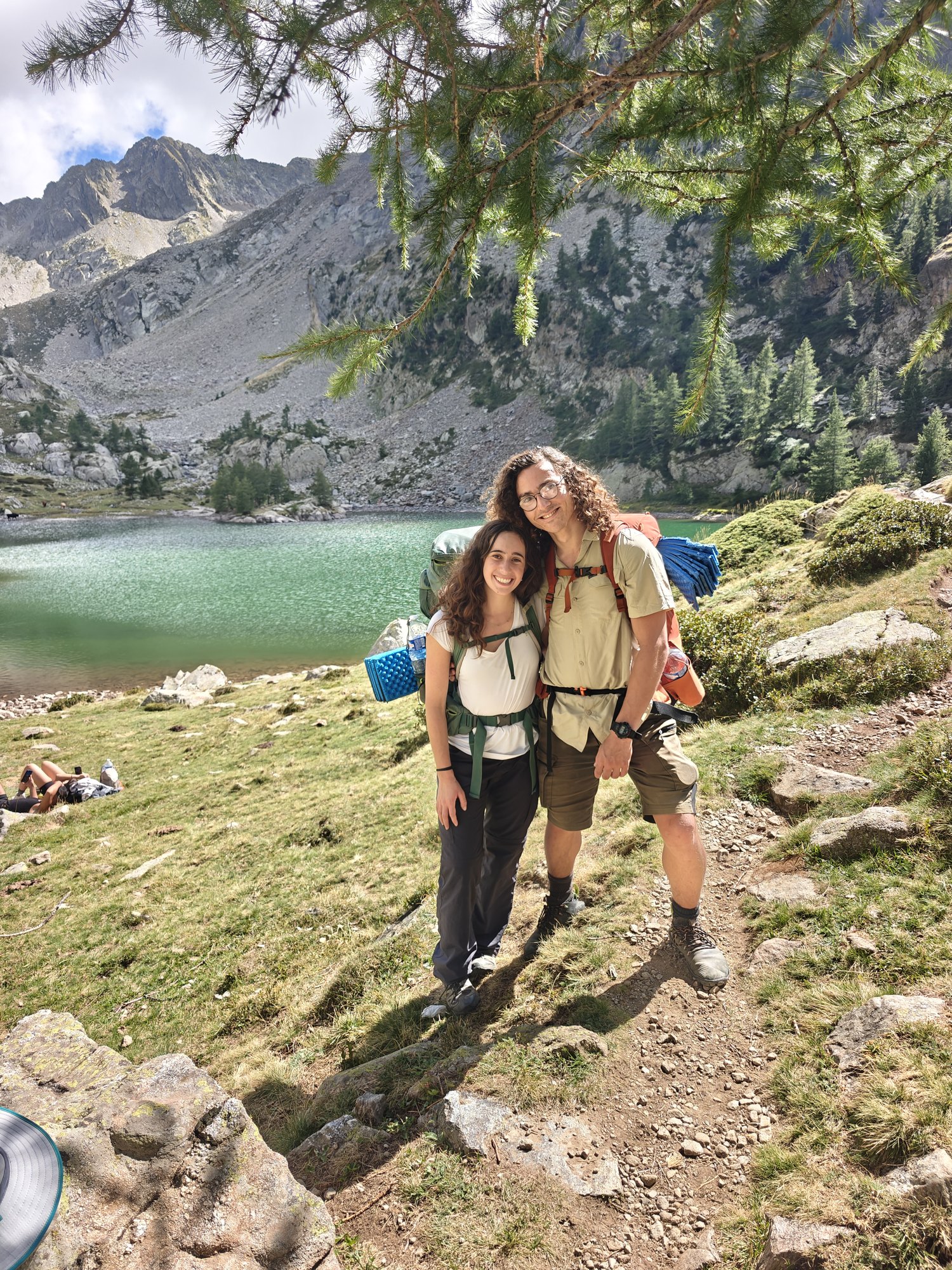
GR52 + a tent
Yarden and I planned a walk with a tent, sleeping and cooking outside. We like sleeping in special places in nature, and we did not want to tie ourselves to booked huts. It keeps the days flexible, it is cheaper, and the money goes to food and small luxuries instead.
The Mercantour park is part of the French Maritime Alps. Through it runs the GR52, about 100 km long, a variation on the finish of the longer GR5, which runs from Geneva to the sea at Nice. The walk takes seven days.
Days
Nice → tram → shopping → bus 90 → Saint-Dalmas
We flew to Nice and were in the city by 11:30. From the airport the L2 tram took us to the centre, Jean Médecin stop, in 25 minutes. We bought the tickets in the Lignes d'Azur app, 1.70 € per person per ride.
From there we went to visit friends who live in Nice and shopped at an Intermarché, fairly large with a good range. It had no gas, so we went on to a Decathlon in the area and stocked up there.
Then the L3 tram to the University stop, and from there bus 90, which leaves Nice three times a day (08:10, 16:30, 18:30) for Saint-Dalmas, where the trek starts. We took the 16:30 bus: two hours of very winding, interesting and beautiful road.
In Saint-Dalmas we slept at the HI hostel Le Chalet, with dinner and breakfast. Dinner was fried fish, rice and beans: a simple meal, fine, a little pricey.
Bus 90 from the University tram stop, three times a day on weekdays; the 16:30 one makes the hostel's 19:00 check-in.
Buy six days of food and the gas in Nice (we took rice, lentils, salami, cheese, carrots and onion), so that the huts are extras. We found gas at Decathlon.
Saint-Dalmas → Col de Veillos → Lac Petit → Col du Barn → Lac du Boréon
Up at 07:00, breakfast at 07:30. For two simple Israelis who know a thing or two about falafel, this was an excellent breakfast! Croissants fresh from the oven, baguettes, sausage and cheese. Six croissants between us. Wow.
On the trail at 08:30. A tough start, a serious climb of about 900 m towards Col de Veillos. From there we took a variant of the trail to reach Lac Petit (not that small at all). The lake is lovely and Yarden went in. Freezing!!!
We kept climbing past a few more lakes to Col du Barn, the high point of the day at 2,452 m, and from there started down. The descent is lovely. A little below the col there is a lake off the path called Lac du Barn, and it is well worth going to. Simply gorgeous: we stopped there for an hour and a half, a proper picnic and even a dip in the icy water!
Down through the forest. Right by the path runs a very pretty stream, and Yarden was annoyed that the path did not follow it, and could not see why. After about half an hour we reached the road and understood that it stays with us all the way to our destination, Lac du Boréon. A bit of a letdown, since walking along a road is dull, so Yarden suggested leaving the path and walking beside the stream. We got close to it, and it really was wild, but we also found out why the path keeps away: the whole bank is bog, from the water running down into it off the slopes. We followed the stream a little until our shoes were soaked, and decided (at my desperate request) to go back to the road.
Another 5 km or so on paths beside the road, through an enchanted forest that I did not like, not enough sunlight, and Yarden loved. On the way we met a family of nice French people who, after a deep chat in Frenglish, gave us a lift to Lac du Boréon. The last kilometres are fairly dull and unnecessary, so if a lift comes along, take it.
We pitched the tent next to the artificial lake. There are a few guesthouses there too, for anyone who wants one. In 2019 a very serious storm hit the area and wrecked some of the paths and the infrastructure, and the lake is still being repaired!!!
In the evening we went to the restaurant by the lake, L'Eau à la Bouche, which the internet said was well regarded, expensive and heavy on meat, as Yarden demanded (while Ayelet wanted rice and lentils). The restaurant was pleasant and impressive. We chose two mains: an entrecôte steak and a kind of double meat patty which, the waiter said, is cooked outside and raw inside. We did not expect what came: it turns out this is a restaurant that specialises in serving raw meat, on the strength of ingredients good enough to allow it. We got completely raw minced meat and a steak it would be illegal to serve in Israel (we had asked for medium). I was utterly shocked, Yarden rather enjoyed it, but we both agreed it was an experience we probably will not repeat. Still, an experience, and educational. The meal cost us 52 €.
Lac Petit and Lac du Barn are both off the path and both worth it.
The last 5 km are road; take a lift if one stops.
Le Boréon → Refuge de la Cougourde → Lac de Trécolpas → Pas des Ladres → Lac de Fenestre
Up in our lovely tent at 07:15, packed and off. We looked for coffee in the huts nearby and found nothing worth it, and Yarden, who needed one, was not pleased.
We started the climb at 09:00. It begins in a forest (full of mushrooms) and goes on through open country with a dramatic view of the mountains and a stream running down with endless pools. The climb was one of the highlights of the trip: hard walking, but it pays back in full. At one of the pools on the way we even went into the water. Cold, but wow.
We climbed to Refuge de la Cougourde and got there at 12:30. A lovely refuge. After the climb we bought a coffee and a blueberry and raspberry tart, good (and expensive) but highly recommended.
We rested with the view and carried on up to Lac de Trécolpas. The lake was gorgeous, beyond anything we had seen so far. We chose a hidden corner, rested and had lunch.
After a lovely long break, watching the chamois and exploring the area, we carried on around 15:30 to Pas des Ladres.
We decided to sleep by Lac de Fenestre, which the trail does not pass directly. We saw there is a path around that runs along the Italy–France border, and decided a high five to Italy was a good idea. The way was challenging and nice.
We slept at a spot overlooking the lake, next to ruined buildings from the Second World War. We arrived at 17:15, pitched the tent and ate rice and lentils.
No coffee at Le Boréon in the morning; start early, the climb to Cougourde is long.
Sleeping above Lac de Fenestre: flat ground by the old barracks.
Lac de Fenestre → Pas du Mont Colomb → Refuge de Nice → Baisse du Basto → Lac du Basto
Up, coffee in the tent, packed, and off to fill water at the trickle Yarden had found the day before, also known as the pure cloud-juice press. We started down and took a variant of the trail that cuts the visit to the Madone de Fenestre hut and goes straight to Pas du Mont Colomb. On the way we stopped at the stream, found an amazing pool and bathed, and once refreshed we started the big climb to the pass, technical and nice.
We reached the pass at 12:00 and had lunch. Then we went down and reached Refuge de Nice at 14:30. The refuge sits in a lovely spot on the mountainside, straight out of a film. We sat down for a coffee with a tart: the coffee was awful and the tart a B minus. Coffee lovers like us should bring their own to make; the French do not make coffee that well (in the huts, at least). We thought of sleeping at the refuge, but it turns out the beds are in shared dorms only, and we, spoilt as we are, like our privacy.
The plan was to end the day at the refuge and have an easier day, but we felt we still had strength (at least 50 % of us did) and decided to go on a little. After a quick and not very deep look at the map we decided to go to Lac du Basto; a few hundred metres of climbing later we realised you actually have to cross another pass to get there, Baisse du Basto (500 m up and 400 down). In short, our chill day turned into a fairly tough one, but we enjoyed the technical walking and the views. Note: towards evening fog starts to form on the high parts of the mountains, worth bearing in mind.
We reached a lovely lookout over the lake a little after 18:00, stopped there and pitched the tent.
Skip the Madone hut and go straight to Pas du Mont Colomb.
Going on past Refuge de Nice means Baisse du Basto the same afternoon, 500 m up; fog comes towards evening.
Lac du Basto → Vallée de la Valmasque and back → Refuge des Merveilles
We decided to change the original plan. We had seen that along the GR52 there is a valley called Valmasque which the trail reaches but does not go through. On the map it looked like a very pretty stretch with three big lakes one after the other, and the French family we met on the first day had recommended it too. So we decided to do the valley out and back, and then carry on to Refuge des Merveilles.
We highly recommend this extension: the lakes are stunning, and it is a joy to go into the water and sunbathe on the soft grass at the lakeside. The hut there is cute too, and if you like you can carry on along another route that goes down to pretty waterfalls (we did not).
Back on the trail, we climbed up and then down into the Merveilles valley. The valley is very beautiful and magical. It is known as one of the sites with the oldest rock engravings, from the Bronze Age. We managed to find very few of them; you are welcome to look for more.
Next to the Merveilles hut there is one marked area, above the hut, and only there may a tent be pitched, unlike the other sectors of the route, where you can pitch a tent almost anywhere. At the hut we had a meaty dinner, simple but tasty and filling (the meat well done, no worries), 21 € each. Dinners in the huts are usually very social and communal.
We came out of dinner in the dark and found the whole valley in fog. We had pitched the tent quite far away, so we had to feel our way to it in the murk. The head torches helped us see 2 m ahead instead of 1... In the end, after walking in circles and a bit of arguing, we found the tent and went to sleep!
The Valmasque valley out and back is the best half day of the trek.
In the Merveilles valley stay on the trail; the tent goes only on the marked area above the refuge, dinner 21 € each.
Pitch close to the hut: fog fills the valley after dark.
Merveilles → Lac de la Muta → Lac du Diable → Pas du Diable → Authion ridge → Camp d'Argent → a ledge beyond
We woke at Merveilles and went to the hut for coffee. It came in bowls, quite a cute concept. Breakfasts in the huts are usually fairly plain: cornflakes, bread, jam and coffee.
We started climbing and reached Lac de la Muta, the last big lake of the trip. Worth sitting and watching it for a while, and even going in. Note that the whole area is a kind of nature reserve where you are not supposed to leave the paths, but we chose to read a swim in the lake as a separate activity. After another climb you reach Lac du Diable (the devil's lake) right by the pass, which really is the last lake of the trip.
After Pas du Diable, for the whole rest of the way, we walked in heavy fog and could not see a metre. The walking is very beautiful, along the mountain ridges, but we saw very little in the few windows of sun. A storm was forecast for that day and never came, and above all we made sure not to be at the day's high point, Pas du Diable, in the dangerous hours.
As walking goes the day was fairly easy for us, with far less climbing than on the previous days. We reached the Camp d'Argent hut at 15:30. They serve an excellent local beer, brewed in the Mercantour park. We found there is a camping area next to the hut, and checked on dinner too: they offer ready meals to heat yourself in the microwave, which did not appeal much. We decided to go on, find a more secluded spot to sleep and cook for ourselves.
We carried on along the trail (part of the next day's route, towards Sospel) and found a lovely patch of grass, fairly flat (the whole area is quite steep) and out of the wind, with a stunning view, and stopped there. At the hut they had told us there is a cheese shop further along. We checked the map and there really is, but it looks to be in a completely random spot, among ancient ruins in the middle of the mountain. We will look into it tomorrow.
No water from Lac du Diable to Camp d'Argent: 4.5 L each.
Be over Pas du Diable before the afternoon if a storm is forecast.
Past Camp d'Argent there is a flat, sheltered ledge, the best tent spot of the trip.
The ledge → cheese farm → Mangiabo → 1,500 m down → Sospel
We woke to a wonderful sunrise. We walked through the forest, with the sun peeking between the trees, to a water point marked on the map. It looks a little dubious, but the water was good and tasty. It is important to set out on this day with fairly plenty of water, since the route is long, you go down low and the temperatures rise.
We found the cheese shop (Cheese Shop on the map): right inside a small sheep farm, with a small sign. We saw a father and son eating a breakfast of baguette, cheeses and sausage, and asked them "English?" They answered "No". We asked "Cheese?" and they answered "Yes!" They led us to their cheese "cellar", where there were three kinds of cheese. We tasted each and in the end took a little of them all. Recommended!
We went on, and the way opened up to a view of forested mountains, up to the summit of Mangiabo, where we stopped for lunch at 12:30. We saw there is a narrow path along the crest of the ridge, instead of the official path that runs beside the summits, and that the two join after a few kilometres. We chose it because we wanted a better view, and challenging walking does not scare us. Very quickly the path vanished and we were left to feel our way, and still the "way" was amazing: a stunning and varied view, with special trees and flowers wrapped around us. We felt we had entered the path of magic and fairies.
Where the paths joined, by the remains of an old cannon, we began the big descent of the day to Sospel: about 1,500 m!!! Walking poles recommended, from the shop or picked up in the forest. The descent was long and very hard, and we started to feel the heat. It took us 3 hours in all, and we reached the town at 17:30, exhausted but happy.
We had not booked anywhere to sleep, and after some searching it turned out there are no hostels or hotels in Sospel (the last hotel closed a while ago). We booked an Airbnb: a studio room in the centre of town for 300 ₪ a night, cramped but it did the job.
The town is lovely, full of plane trees, with a cute stream through the middle and plenty of vines and fruit trees. At the Spar we bought sausages and cheeses for the next day, and even a pastry from a lovely bakery called Artisan Boulanger Pâtissier. On the main street there are two fairly similar restaurants serving pizzas and burgers, and to our great surprise both close at 20:30! So mind you go to eat fairly early. We ate at Sousper (as the last customers of the day), and it was very tasty.
Sospel → Col du Berceau → Menton
We woke to a long, intense day of walking. We opened the morning with three croissants, an apple pastry and coffee at a cute bakery in town, and set off.
The whole start of the route is a climb through an enchanted, magical forest, until you reach the ridge, and there, for the first time, the sea at Menton opens up in front of you! From there you feel the Mediterranean landscape, a little like the scenery we know from home, only much more impressive. Walking among masses of vines, blackberries and olive trees.
At 14:40 we reached Col du Berceau and the start of the big descent, 1,080 m down to Menton. It took us about 3 hours, and we reached the sea at 17:30. Bring a swimsuit!
Menton is famous for its lemons, which are supposed to be especially sweet and juicy.
No water between Sospel and the sea: 4.5 L each.
Bring a swimsuit; the beach is the finish.
Undated pictures
Wrap-up
All in all, a very successful trip: fun, interesting walking, plenty of water and a wide range of scenery. It is fairly demanding; you walk a great deal every day, with a lot of climbing and descending.
It was nice to meet groups of walkers who, like us, were doing the trail with a tent.
Before you go
When. Mid September was right: warm days, the huts still open, few people.
Park rules. From Col du Barn to just past Pas du Diable you are in the park core: a new spot each night. In the Merveilles valley stay on the trail and camp only on the marked area above the refuge.
Water. 3 L each was enough on days 1 to 4. We recommend 4.5 L from Refuge des Merveilles to Camp d'Argent and from Sospel to Menton, the two dry stretches.
Food. We carried six days of food from Nice so that we did not depend on the huts: rice, lentils, salami, cheese, carrots and onion. The huts were extras.
Sleeping. Our nights: the hostel in Saint-Dalmas, the lake at Le Boréon, above Lac de Fenestre, above Lac du Basto, the bivouac area at Merveilles, the ledge past Camp d'Argent, an Airbnb in Sospel. A sleeping bag and a mat.
Gear. Walking poles: we did not bring any and wished we had on the long descents to Sospel and Menton, so take a pair. Offline maps: the GPX from this page in any map app that reads GPX files.
Weather. Check the Météo-France mountain bulletin the evening before.
Links
Trip reports in Hebrew. Sipur Derech, six days on the GR52 with the options for shorter loops. Floating in Provence, the Merveilles valley and the Mercantour, background and practical notes.
Trip reports. Happily Ever Travels, six days wild camping in August. Backpacking Light, track notes stage by stage. Ian Chappell, a walk with pictures. Altitude Rando, mid September, campsites and refuges. Randonner Léger and Larche to Menton, ultralight bivouac, in French. GR Five, the best description of the Sospel descent. Crossing the Alps with Ease, refuges. Howlingmist, late October, the cold end of the season. In French: Happytrek, four days in bivouac; Toporando, the last part of the Grande Traversée des Alpes; La Vie Sauvage, stages and difficulty.
Official. Mon GR, Topo de Rando and GR Infos for the stages. Park rules FAQ, the bivouac order and the Merveilles zone. Trail notices from the park, worth a look the week before.
Whole route
Upload pictures
Pictures go straight into this log, one by one or as a zip (a Google Photos album download works as is). The date and place come from the picture itself; captions and the day can be set afterwards in the log file.